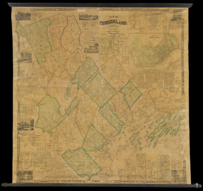
Map of Cumberland County Maine
Collection: Osher Map Library Collection
Name: Map of Cumberland County Maine
Barcode: 13284
Creator: Baker, SidneyChace, J.
Publishing Location: Portland, ME
Notes: Note under title: "From Actual Surveys, by Sidney Baker, C.E. and Others. J. Chace Jr. Publisher 1857."Insets: "Bartol's Point Landing and Village," "Back Cove Village," "Bolsters Mills," "Bridgton Center," "Brunswick," "Casco Village," "Cumberland Center," "Edes Mills," "Falmouth Corner," "Freeport Village," "Gorham Village," "Gray Corner," "Great Falls," "Harraseeket Landing, Freeport," "Harrison Village or head of Long Pond," "Little Falls," "Naples, or foot of Long Pond," "New Glocester Center," "North Bridgton," "North Pownal," "Piscataqua Village, Falmouth," "Plan of Portland," "Saccarappa," "Sawyer's Corner," "Standish Corner," "Stevens Plains Village (Westbrook)," "Stroudwater," "Strout's Point Village," "Webbs Mills," "Woodfords Corner," "Upper Glocester," "Yarmouth Village."
Publisher: Chace, J.
Date/Date Range Produced: 1857
Date/Date Range Published: 1857
Language: English
Region Depicted: Cumberland County, Maine
Map Type: Wall maps
Dimensions: 139 x 98
LC Call Number:
OCLC:
Permenant URL: https://oshermaps.org/map/13284.0001