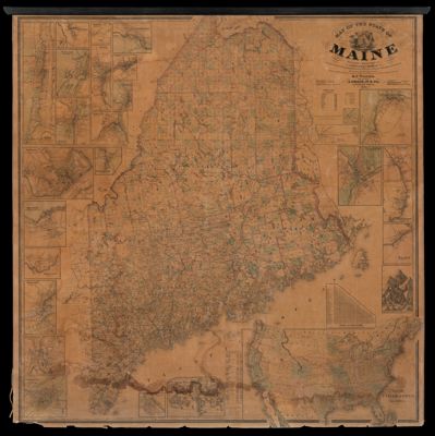
Map of the State of Maine from surveys made by the United States Coast Surveys
Collection: Osher Map Library Collection
Name: Map of the State of Maine from surveys made by the United States Coast Surveys
Barcode: 13287
Creator: Walling, Henry Francis, 1825-1888
From Atlas: No
Publishing Location: Portland, ME
Publisher: Chace, J.
Date/Date Range Produced: 1861
Date/Date Range Published: 1861
Language: English
Region Depicted: MaineUnited StatesWorld
Map Type: Wall maps
Dimensions: 132 x 125 cm
LC Call Number:
OCLC:
Subjects: Auburn (Me.)Augusta (Me.)Bangor (Me.)Bath, MaineBiddeford (Me.)Brunswick (Me.)Calais (Me.)CensusCountiesEastport, MaineEllsworth, MaineFarmington (Me.)Hallowell, MELewiston (Me.)Machias, MaineMainePortland (Me.)Saco (Me.)Skowhegan (Me.)Thomaston, MaineWaldoboro (Me.)White Mountains (N.H. and Me.)World
Permenant URL: https://oshermaps.org/map/13287.0001