Map of the Town of Frankfort Waldo County Maine
Collection: Osher Map Library Collection
Name: Map of the Town of Frankfort Waldo County Maine
Barcode: 13303
Creator: Osborn, D. S.Woodford, E. M.
From Atlas: No
Publishing Location: Philadelphia
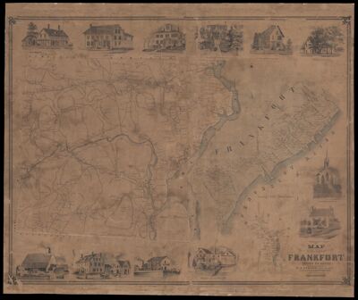
Notes: Lithographed wall mapNote: "Printed by Wagner & McGuigan."Images of places of interest around the borders: Lathley Rich's Residence, Stokell's Block, Residence of Jeremiah Holme, Residence of N.H. Hubbard Esq., Residence of Otis Kaler, Residence of Amos Sprout, Congregational Church, Residence of T. Cushing, Residence of Capt. W.M.S. Smith, Rich's Wharf, Commercial House, T. Cushing and Cos Steam Mill
Publisher: Woodford, E. M.
Date/Date Range Produced: 1855
Date/Date Range Published: 1855
Language: English
Region Depicted: Frankfort, Maine
Dimensions: 98 x 83 cm
LC Call Number:
OCLC:
Subjects: Frankfort, MainePenobscot River (Me.)Waldo County (Me.)
Permenant URL: https://oshermaps.org/map/13303.0001