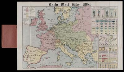
Daily Mail War Map
Collection: Osher Map Library Collection
Name: Daily Mail War Map
Barcode: 50140
Creator: George Philip & Son
Date/Date Range Produced: 1918
Date/Date Range Published: 1918
Language: English
Dimensions: 57 x 86 cm
Notes: On right margin: "War Strength of the Great Powers: Armies, Navies, Aircraft, War Funds Available, Peace strength of the Great Powers, Armies of other European States."
Left and right lower margins: "George Philip & Son, Ltd., The London Geographic Institute"
LC Call Number: G5701.S65 1918.D34
OCLC: 76891085
Accession Number: OML-1918-104
Subjects: World War, 1914-1918
Permenant URL: https://oshermaps.org/map/50140.0001