Victory War Map
Collection: Osher Map Library Collection
Name: Victory War Map
Barcode: 50162
Creator: Geographical Publishing Co.New England Homestead (Firm)
From Atlas: No
Publishing Location: Chicago
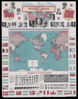
Notes: Maps: The World; United States Army and Navy Camps and Stations; Asia; Pacific Ocean on Mercator Projection; Commonwealth of The Philippines; Eastern China; Japan; New Map of Central Europe; Excelsior Series Map of United States and Alaska. Also, large image of flag with Pledge of Allegiance, Star Spangled Banner, and Flag Code.
Portraits of world and military leaders on the first page: General Chiang Kai-Shek; General Charles de Gaulle; General A. Vandegrift; Admiral Lord Louis Mountbatten; Prime Minister Clement R. Attlee; Premier Josef Stalin; General H. H. Arnold; Fleet Admirals Chester W. Nimitz and WM. D. Leahy; Generals Dwight Eisenhower Douglas MacArthur and George C. Marshall; President Harry S. Truman; Fleet Admiral Ernest King; General Sir Thomas Blamey; Admiral of the Fleet Sir Andrew B. Cunningham; Field Marshal Sir B. L. Montgomery; Marshal Grigory Zhukov; General Chen Cheng
Allied countries maps around the border of first image with U.S.A. Armed Forces Insignias along the bottom
Bottom of fifth image is the census showing the populations with data of the largest cities in the world
Publisher: Geographical Publishing Co.
Date/Date Range Produced: 1945
Date/Date Range Published: 1945
Language: English
Region Depicted: AsiaChinaEuropeJapanPacific OceanPhilippinesUnited StatesWorld
Map Type: Wall maps
Dimensions: 88 x 71 cm
Accession Number: OML-1945-134
Subjects: AsiaCensusChinaEuropeJapanMilitary campaignsPacific OceanPhilippinesWorldWorld War, 1939-1945
Permenant URL: https://oshermaps.org/map/50162.0001; 50162.0002; 50162.0003; 50162.0004; 50162.0005; 50162.0006