The Five Zones Showing in a Graphic Manner the Climates, Peoples, Industries & Productions of the Earth
Collection: Osher Map Library Collection
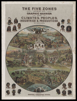
Name: The Five Zones Showing in a Graphic Manner the Climates, Peoples, Industries & Productions of the Earth
Barcode: 35951
Creator: Yaggy, L. W. (Levi W.)
Publisher: Western Publishing Company
Publishing Location: Chicago, Ill.
Notes: Sheet map from Yaggy's Geographical Study (OML-1887-37; OCLC # 431347062)Shows zones of the earth: "Arctic Zone," "North Temperate Zone," "Torrid Zone," "South Temperate Zone," "Antarctic Zone" and illustrations of native peoples.
Date/Date Range Produced: 1887
Date/Date Range Published: 1887
Language: English
OCLC: 431347062
Accession Number: OML-1887-37.11
See Also: Map of Africa designed especially for class work, recently compiled from the latest and most reliable sources.Map of Asia designed especially for class work, recently compiled from the latest and most reliable sources.Map of Eastern Hemisphere with four globes, showing north and south circumpolar area. Also rain-fall, winds, vegetable products, animal life, etc., in different sections of the earthMap of Europe designed especially for class work, recently compiled from the latest and most reliable sources.Map of North America designed especially for class work, recently compiled from the latest and most reliable sources.Map of South America designed especially for class work, recently compiled from the latest and most reliable sources.Map of Western Hemisphere with four globes, showing showing land and water hemispheres. Also rain-fall, winds, vegetable products, animal life, etc., in different sections of the earthPlanetary System. Eclipse of the Sun. The Moon. The Zodiacal Light. Meteoric Shower.Yaggy's Geographical Study: comprising physical, political, geological and astronomical geography
Permenant URL: https://oshermaps.org/map/35951.0001