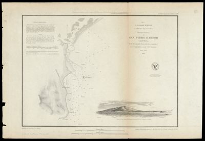
Reconnaissance of San Pedro Harbor, California U.S. Coast Survey by the Hydrographic Party under the command of Lieut. Comdg. James Alden, U.S.N. Assistant
Collection: Osher Map Library Collection
Name: Reconnaissance of San Pedro Harbor, California U.S. Coast Survey by the Hydrographic Party under the command of Lieut. Comdg. James Alden, U.S.N. Assistant
Barcode: 36570
Creator: Bache, A. D. (Alexander Dallas), 1806-1867
Publishing Location: Washington D.C.
Notes: Inset: View of San Pedro, Pt. Fermin bearing W.N.W. (Compass) 4 milesNotes: "Presented under Authority of an Act of Congress of the United States of June 3d.1884 & by direction of the Treasury Department A.D. Bache Superintendent Coast Survey." "Electrotype Copy No. 1 by G. Mathiot U.S.C.S." "J No. 5" ""The astronomical observations were made in 1852 by Geo. Davidson, Assist. U.S. Coast Survey ; the sketch work of the shore and view were executed by W.B. McMurtrie."Below neat line: "Reduction for engraving by Frs. Herbst ; outlines & topography engraved by H.C. Evens ; view by S.V. Hunt ; lettering by S.E. Stull."
Date/Date Range Produced: 1852
Date/Date Range Published: 1852
Language: English
Region Depicted: San Pedro Bay, California
Map Type: Nautical charts
Dimensions: 28 x 42 cm
LC Call Number: G4364.L8:2526 .U5
OCLC: 24868812
Permenant URL: https://oshermaps.org/map/36570.0001