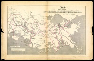
Map of a part of the State of Louisiana exhibiting the route of the New-Orleans, Opelousas & Great Western Rail Road
Collection: Osher Map Library Collection
Name: Map of a part of the State of Louisiana exhibiting the route of the New-Orleans, Opelousas & Great Western Rail Road
Barcode: 45811
Creator: Bayley, G.W.R.
Publisher: Childs & Hammond
Date/Date Range Produced: 1853
Date/Date Range Published: 1853
Notes: Mississippi delta area shows drainage, sugar crop, parishes, major cities and towns, canals, and railroads with lines named and distances on the main line. This railroad was opened for first 50 miles on March 6, 1854. It was purchased in 1878 by the Morgan's Louisiana and Texas Railroad.
OCLC: 5572092
Accession Number: OML-1853-33
Donor: Maine Historical Society
Permenant URL: https://oshermaps.org/map/45811.0001