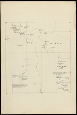
The Fifteenth Section No. 1 Lake Huron 1820 & 21
Collection: Osher Map Library Collection
Name: The Fifteenth Section No. 1 Lake Huron 1820 & 21
Barcode: 38555
Publisher: United States. Light-House Board
Date/Date Range Produced: 1891
Date/Date Range Published: 1891
Dimensions: 29.5 x 54
Notes: "We certify this to be a true map of part of the Boundary designated by the sixth article of the Treaty of Ghent from actual Survey by order of the Board."
Accession Number: OML-1891-52.13
Donor: USM Geo/Anthro Department
Permenant URL: https://oshermaps.org/map/38555.0001