Collection: Osher Map Library Collection
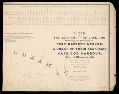
Name: A map of the extremity of Cape Cod : including the townships of Provincetown & Truro, with a chart of their sea coast and of Cape Cod Harbour, State of Massachusetts
Barcode:
Creator:
Date/Date Range Produced:
Date/Date Range Published:
Language:
Region Depicted:
Printing Process:
Printing Technique:
Material Type:
Accession Number: OML-1836-18.2
Donor:
Permenant URL: