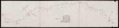
A plan of the roads between Boston and Penobscott Bay surveyed by order of the Governor in pursuance of a Resolution of the General Court of the Massachusetts-Bay
Collection: Osher Map Library Collection
Name: A plan of the roads between Boston and Penobscott Bay surveyed by order of the Governor in pursuance of a Resolution of the General Court of the Massachusetts-Bay
Barcode: 49913
Creator: Bernard, Francis, Sir, 1712-1779
From Atlas: No
Notes: Key to two symbols for county towns and churches or meeting-houses, large compass rose on the first sheet, showing magnetic variation for 1765, the road following for much of its course the route of present day route 1, showing principal settlements en route, mileages each mile from Boston (210 miles to Penobscot Bay). 1st image is a composite of the maps, showing how they go together.
Surveyor: Miller, Francis
Date/Date Range Produced: 1765
Date/Date Range Published: 1765
Language: English
Region Depicted: MaineMassachusetts
Map Type: Manuscript maps
Printing Technique: Manuscript
Material Type: Paper
Accession Number: OML-1765-8
Permenant URL: https://oshermaps.org/map/49913.0001