Collection: Osher Map Library Collection
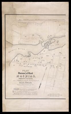
Name: Plan and division of land at Machias, into streets and lots; also a profile presenting the level of a proposed railroad surveyed and drawn by Wm. Anson.
Barcode:
Printmaker:
Surveyor:
Date/Date Range Produced:
Date/Date Range Published:
Language:
Dimensions: H 76 x W 53
Notes:
LC Call Number: G3734.M24 1835 A5
Accession Number: OML-1835-42
Permenant URL: