Collection: Osher Map Library Collection
Name: Farm and Fireside : The National Farm Magazine [3 large sheets designed for wall-hanging, containing maps and other information]
Barcode: 43034
Creator: Farm & Fireside
From Atlas: No
Publishing Location: Springfield, OH
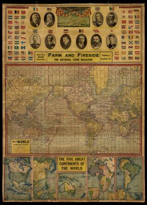
Notes: 1) "Kenyon's Unrivaled Map of North America showing routes via Panama Canal," 2) "Map of south America according tho the Latest Official Sources and most recent maps of exploration," 3) Map of the united States showing Banking Towns, Railroads, Rivers, Mountains, Steamship Lines, and Belts of Standard Time," 4) Reconstructed Map of Europe, Asia Minor, and Northern Africa . . . showing new nations and boundary changes," 5) "General Pershing's Secret Battle Map," and "Map of the Atlantic Ocean showing Route of the American and British Flyers," 6) "Map of the World on Mercaotrs Projection," and "The Five Great Continents of the World" Portraits of world leaders included on the first image with "Flags of all the Nations" surrounding them: Alexandre Millerand, President of France; Warren G. Harding; George V.; Victor Emanuel III., Italy; Yoshihito, Japan; General Jozes Pilsudski, President of Poland; Albert I., Belgium; Frederick Ebert, President of Germany; Haakon VII., Norway; Gustav V., Sweden. Page 2 includes image of flight paths across the Atlantic Ocean with image and information about A.C. Reed who was the first man to cross the Atlantic and his plane. Portraits of Military leaders on third page: General Armande Diaz, Commander-in-chief of Italian Armies; General Foch, Marshal of France, Commander in Chief of Allied Armies; Rear Admiral Sir David Beatty, Commander of England's Grand Fleet; Henry T. Mayo, Admiral of United States Navy; Admiral W. S. Benson, Chief of Naval Operations; General Petain, Commander-in-Chief of the French Armies; General John J. Pershing, Commander-in-Chief of the American Forces in France; Sir Douglas Haig, Commander-in-Chief of British Forces. Insets included: Western War Region; Gibraltar British Fortification; The Suez Canal and the Cairo Region; "The Keyhole of Europe" from Dardanelles to Hellespont; The Kiel Canal and the German Shipping District. Images on the Third Page: U. S. S. "Maryland," Latest Type of Battlecruiser; "One of the great American guns in action on the Western Front"; "Allied Troops marching to the front"; "Our First Line of Defense." United States super dreadnoughts in battle formation. Image on the bottom of Fourth Page: "Chief National Automobile Highways shown on this map by red lines and numbers. Official markers for these highways shown below". Insets on the Fourth Page: Alaska; Panama; Panama Canal; Puerto Rico. Insets on Fifth Page: Panama Canal Zone; Orographic and Climatological Map of South America; Rio de Janeiro; Buenos Aires; Santiago and Vicinity; Valparaiso; Galapagos Islands. Images on Fifth Page: Municipal Theatre, Rio de Janeiro, Capital of Brazil; Passenger Landing, Rio de Janeiro, Capital of Brazil; General View of Asuncion, Capital of Paraguay; The "Plaza Constitucion,"Montevideo, Capital of Uruguay; Steamer Passing Through Basin to Dock, Buenos Aires, Capital of Argentina; Esplanade 8 Miles Long Around the Bay at Cost of $10,000,000; Valparaiso, Leading Port of Chile, City Square; Public Square, Lima, Capital of Peru; Harbor and City of Guayaquil, Ecuador; Presidential Palace, Bogota, Capital of Colombia; Palace of Justice, Caracas, Capital of Venezuela. Sixth Page contains insets: Newfoundland; Puerto Rico; Alaska and the Yukon District; Panama. Images of the Sixth Page: Battleship "New York" 27,000 tons; New York City, Statue of Liberty - Entrance to New York Harbor; Charleston, Massachusetts, Submarine Fleet Lying in Navy Yard; Philadelphia, Pennsylvania, Independence Hall; Montreal, Canada, The Great Harbor; Boston, Massachusetts, Celebration of "Patriot's Day"; Portsmouth, New Hampshire, Launching of Three Wooden Steamers; Washington, D.C.; Washington, D.C., View of New War Government Buildings Taken From the Washington Monument; Chicago, Illinois, Great Lakes Naval Training Station in That City; Havana, Cuba, Cuban Soldiers Marching in Inauguration Parade; New York, Naval Parade; The Plaza, City of Mexico City, Mexico; The National Capital, Washington, D.C.; Houses of Parliament, Ottawa, Canada; Philadelphia, Pennsylvania, View of Liberty Loan Parade Going Down Broad Street; Panama Canal, U.S. Battleship "Missouri" Passing Through Culebra Cut; El Paso, Texas, View of City and Fortified Mountains Commanding the International Bridge and Juarez, Mexico; Mexico City, Mexico, American Consulate; San Francisco, California, Sailors Escorting Men on Second Draft Down Market Street; Alameda, California, Four Big Freighters, Ready for Launching; Near Philadelphia, Hog Island Navy Yard; Seattle, Washington, Pioneer Place; Portsmouth, Virginia, Navy Yard; Panama Canal, Gatun Lake Upper Lock Gates are Shown Opening; New York City, High School Girls in "Wake-up America" Parade; Entrance of Golden Gate, San Francisco, California. Time Zones for different cities are listed in relation to Washington, D.C.
Publisher: Farm & Fireside
Date/Date Range Produced: 1921
Date/Date Range Published: 1921
Language: English
Region Depicted: AfricaAsiaAustraliaEuropeNorth AmericaSouth AmericaUnited StatesWorld
Map Type: Wall maps
Accession Number: OML-1921-64
Subjects: AfricaAsiaAustraliaCensusEurope --HistoryFarmingmagazinesNorth AmericaSeattleSouth AmericaTime --Systems and standardsUnited StatesWorldWorld War, 1914-1918
Permenant URL: https://oshermaps.org/map/43034.0001; 43034.0002; 43034.0003; 43034.0004; 43034.0005; 43034.0006