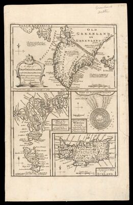
A Map of Old Greenland or Østerbygd & Westerbygd, agreeable to Egede's late Description of Greenland. by Eman. Bowen.
Collection: Osher Map Library Collection
Name: A Map of Old Greenland or Østerbygd & Westerbygd, agreeable to Egede's late Description of Greenland. by Eman. Bowen.
Barcode: 47985
Creator: Bowen, Emanuel, 1693 or 1694-1767Innys, William
Date/Date Range Produced: 1752
Date/Date Range Published: 1752
Language: English
Dimensions: 13 x 22 cm, 18 x 12 cm, 9 x 10 cm, and 9 x 13 cm, on sheet 46 x 59 cm
Notes: Maps on bottom of sheet have titles: "A Map of the islands of Ferro or Farro according to Jacobson Debes," "A Draught of the Whirlpool on the South East of Sumbo Rocks wth. the soundings," "An Improved Map of Iceland."
Prime meridian on map of old Greenland: Tenerife.
Accession Number: OML-1752-1
Permenant URL: https://oshermaps.org/map/47985.0001