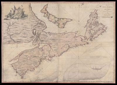
Map of Nova Scotia or Acadia; with the Islands of Cape Breton and St. John's, from Actual Surveys
Collection: Osher Map Library Collection
Name: Map of Nova Scotia or Acadia; with the Islands of Cape Breton and St. John's, from Actual Surveys
Barcode: 49636
Creator: Montrésor, John, 1736-1799
From Atlas: No
Publishing Location: London, England
Notes: What was called St. John's Island at the time is now called Prince Edward Island.Top left corner is an illustration with text: "To the most noble John Manners, Marquis of Granby; Field Marshal Commander in Chief of all His Majesty's forces; Master General of the ordnance, colonel of His Majesty's Royal Regiment of Horfe Guards blue, and one of the lords of His Majesty's moft. Honorable Privy Council: This map with all submission is humbly inscribed by your Lordships most dutiful, most obedient, and most devoted servant. John Montresor, engineer."
Publisher: Dury, Andrew
Date/Date Range Produced: 1768
Date/Date Range Published: 1768
Language: English
Region Depicted: Acadia, New FranceBay of FundyCape Breton IslandNew BrunswickNova ScotiaPrince Edward Island, Canada
Map Type: Wall maps
Dimensions:
LC Call Number:
OCLC:
Subjects: Canada
Permenant URL: https://oshermaps.org/map/49636.0001