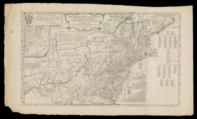
A Map of the Middle British Colonies in North America. First published by Mr. Lewis Evans, of Philadelphia, in 1755; and since corrected and improved, as also extended, with the Addition of New England, and bordering Parts of Canada: from Actual Surveys now lying at the Board of Trade. By T. Pownall MP. with a Topographical Description of such Parts of North America as are contained in this Map. Printed and Published according to Act of Parliament for J. Almon in Picadilly, London. March 25th 1776
Collection: Osher Collection
Name: A Map of the Middle British Colonies in North America. First published by Mr. Lewis Evans, of Philadelphia, in 1755; and since corrected and improved, as also extended, with the Addition of New England, and bordering Parts of Canada: from Actual Surveys now lying at the Board of Trade. By T. Pownall MP. with a Topographical Description of such Parts of North America as are contained in this Map. Printed and Published according to Act of Parliament for J. Almon in Picadilly, London. March 25th 1776
Barcode: 795
Creator: Evans, LewisPownall, Thomas, 1722-1805Turner, James, -1759
Notes: Note: "To the Honourable Thomas Pownall, Esqr. Permit me, Sir, to pay You this Tribute of Gratitude, for the great Assistance You have given me in this Map; and to assure the Public, that it has past the Examination of a Gentleman, whom I esteem the best Judge of it in America: Your most obedient, and most humble Servant, Evans."Note: "Engraved by James Turner in Philadelphia"
Date/Date Range Produced: 1776
Date/Date Range Published: 1776
Language: English
Dimensions: 49 cm. x 83 cm. on sheet 57 cm. x 97 cm.
Printing Process: Engraving
Printing Technique: Copper
Material Type: Paper
LC Call Number:
OCLC:
Donor: Osher
Permenant URL: https://oshermaps.org/map/795.0001