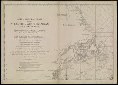
A New and General Chart of the Atlantic or Western Ocean and adjacent seas, including the coasts of Europe and Africa from 60 degrees North Latitude to the Equator, and also the opposite coast of America: Drawn and regulated by the most accurate astronomic observations, and the journals of the most experienced navigators, in which also are particularly distinguished. The determinations of the longitude as given by the marine clocks of Mr. Ferdinand Berthoud, in the voyage performed by order of the government of France, in 1768 and 1769, in the ship Isis, to the Azores, Madera, The Canaries, Cape-Verd Islands, St. Domingo, The Great Bank of Newfoundland, &ca.by Mr. De Fleurieu, an officer in the French Navy and Member of the Royal Marine Academy & ca.
Collection: Osher Collection
Name: A New and General Chart of the Atlantic or Western Ocean and adjacent seas, including the coasts of Europe and Africa from 60 degrees North Latitude to the Equator, and also the opposite coast of America: Drawn and regulated by the most accurate astronomic observations, and the journals of the most experienced navigators, in which also are particularly distinguished. The determinations of the longitude as given by the marine clocks of Mr. Ferdinand Berthoud, in the voyage performed by order of the government of France, in 1768 and 1769, in the ship Isis, to the Azores, Madera, The Canaries, Cape-Verd Islands, St. Domingo, The Great Bank of Newfoundland, &ca.by Mr. De Fleurieu, an officer in the French Navy and Member of the Royal Marine Academy & ca.
Barcode: 801
Creator: Fleurieu, C. P. Claret (Charles Pierre Claret), comte de, 1738-1810
From Atlas: No
Notes: Note at bottom left: "London. Printed for Robert Sayer and John Bennett, Map and Sea Chart Sellers, at No. 53. in Fleet Street. Published as the Act directs, 10th August 1777."
Publisher: Robert Sayer and John Bennett (Firm)
Purveyor: Robert Sayer and John Bennett (Firm)
Date/Date Range Produced: 1777
Date/Date Range Published: Aug 1777
Language: English
Region Depicted: ConnecticutDelawareMaineMaritime ProvincesMarylandMassachusettsMiddle Atlantic StatesNew EnglandNew HampshireNew JerseyNew York (State)Newfoundland and LabradorNova ScotiaPennsylvaniaRhode IslandVermontVirginia
Map Type: Nautical charts
Dimensions: H 53.1 x W 73.8 cm
Printing Process: Engraving
Printing Technique: Copper
Material Type: Paper
LC Call Number:
OCLC: 856541603
Donor: Osher
Permenant URL: https://oshermaps.org/map/801.0001