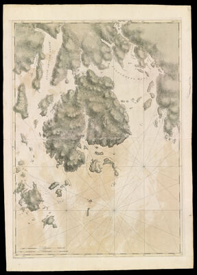
Coast of Maine- Mount Desart Island, Frenchman's Bay, Long Island, Dated July 15, 1776
Collection: Osher Collection
Name: Coast of Maine- Mount Desart Island, Frenchman's Bay, Long Island, Dated July 15, 1776
Barcode: 803
Creator: Anonymous / Unknown Author
From Atlas: No
Notes: Note lower left: "Publish'd According to Act of Parliament July 15, 1776, by J.F.W. Des Barres Esqr." Title supplied by cataloger, no title on map itself.
Publisher: Des Barres, Joseph F. W. (Joseph Frederick Wallet), 1729-1824
Date/Date Range Produced: 1777
Date/Date Range Published: 1777
Language: English
Region Depicted: Frenchman's BayMount Desert Island, Maine
Map Type: Nautical chartsTopographical maps
Dimensions: 107 x 76 cm.
Printing Process: Etching
Printing Technique: Copper
Material Type: Paper
LC Call Number:
OCLC: 43168836
Accession Number: OS-1777-11
Donor: Osher
Subjects: CoastsIslandsMaine--MapsMaps--Early works to 1800Mount Desert Island (Me.)Nautical charts
Permenant URL: https://oshermaps.org/map/803.0001