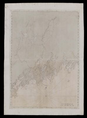
Coast of Maine- From Spurwink River to Moose Point] [Or, from Musketo Island to Cape Elizabeth, inclulding Kennebec River
Collection: Osher Collection
Name: Coast of Maine- From Spurwink River to Moose Point] [Or, from Musketo Island to Cape Elizabeth, inclulding Kennebec River
Barcode: 817
Creator: Anonymous / Unknown Author
From Atlas: No
Notes: Note lower right: "Publish'd According to Act. April 24, 1776 by J.F.W. Des Barres Esqr." Title supplied by cataloger, no title on map itself.
Publisher: Des Barres, Joseph F. W. (Joseph Frederick Wallet), 1729-1824
Date/Date Range Produced: 1777
Date/Date Range Published: 1777
Language: English
Region Depicted: Androscoggin County, MaineCumberland County, MaineKennebec County, MaineKnox County, MaineLincoln County, MaineSagadahoc County, Maine
Map Type: GeographicalNautical charts
Dimensions: 104 x 74 cm.
Printing Process: Engraving
Printing Technique: Copper
Material Type: Paper
Accession Number: OS-1777-5
Donor: Osher
Subjects: Androscoggin County (Me.)Androscoggin River (N.H. and Me.)CoastsCumberland County (Me.)IslandsKennebec County (Me.)Kennebec River (Me.)Knox County (Me.)Lincoln County (Me.)Maine--MapsMaps--Early works to 1800Nautical chartsSagadahoc County (Me.)
Permenant URL: https://oshermaps.org/map/817.0001