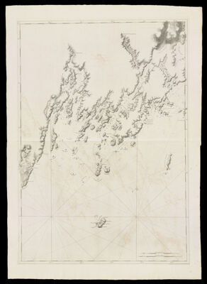
Coast of Maine- From Seal Harbor to Penmaquid Point, Dated June 24, 1776
Collection: Osher Collection
Name: Coast of Maine- From Seal Harbor to Penmaquid Point, Dated June 24, 1776
Barcode: 819
Creator: Anonymous / Unknown Author
From Atlas: No
Notes: Note: "Publish'd According to Act of Parliament June 24th 1776, by J.F.W. Des Barres Esqr." Title supplied by cataloger, no title on map itself.Map shows islands, bays, harbours and other points of interest: Penmaquid Point; Pavement Cove; New Harbour; Long Cove; Browns Head; Round Pond; Carter's Islands; Mash Island; Muskongus Island; Hogg Island; Ram Island; Greenland Cove; Oar Island; Partners of Long Island; Cow Island; Hunger Island; Jones Neck; Broad Cove; Western Creek; Eastern Creek; Broad Bay; Medumac River; Medumac Falls; Farington's Cove; Long Creek; Back Cove; Small Falls; Goofe River; Martin's Point; Hatchet Cove; Sand Island; Jone's Garden; Falfe Franklin; Harbour Island; Franklin's Island; High Ledge; Outward Egg Rock; The Gull Rocks; Manheigin Island; The Old Man and Woman Ledges; Burnt Island; St. George's Harbour; St. George's Islands; Otter Island; Cranberry Island; Minnifters Gutt; Medumcook Island; Carver's Island; Burton's Island; Crotch Island; Carver's Point; Baf's Point; Gaunt Neck Cove; Salt Marsh; Little River; Medumcook River; Pleasant Point; St. George's River; Maple Juice Cove; McCobb's Point; Arnold's Cove; Broad Cove; Cutler's Cove; Smith's Cove; Colvills Island; Herring Gutt; Herring Gutt Island; Mark Island; The Brothers; Mufkeito Island; Mufkeito Harbour; Moofe Point; Northern Island; Tarrents Harbour; Southern Island; Long Creek; The Little Marshes; Little Marsh Cove; White Head Islands; White Harbour; Seal Harbour; Seal Harbour Island; Wassawasgeig River; Owl's Head Bay; Two Bush Island; Metinick Island; Metinick Rock.
Publisher: Des Barres, Joseph F. W. (Joseph Frederick Wallet), 1729-1824
Date/Date Range Produced: 1777
Date/Date Range Published: 1777
Language: English
Region Depicted: Knox County, MaineLincoln County, Maine
Map Type: Nautical chartsTopographical maps
Dimensions: H 106 x W 74 cm.
Printing Process: Engraving
Printing Technique: Copper
Material Type: Paper
LC Call Number:
OCLC:
Donor: Osher
Subjects: CoastsIslandsKnox County (Me.)Lincoln County (Me.)Maine--MapsMaps--Early works to 1800Nautical charts
Permenant URL: https://oshermaps.org/map/819.0001