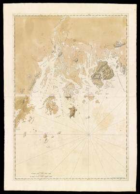
Coast of Maine- From Frenchman's Bay to Musketo Island including Mount Desart and Deer Islands, and Penobscot Bay
Collection: Osher Collection
Name: Coast of Maine- From Frenchman's Bay to Musketo Island including Mount Desart and Deer Islands, and Penobscot Bay
Barcode: 820
Creator: Anonymous / Unknown Author
From Atlas: No
Notes: Note lower right: "Publish'd according to Act April 24, 1776 by J.F. W. Des Barres Esqr." Title supplied by cataloger, no title on map itself.Map includes bays, islands, and other landmarks: Woodenball Rock; Seal Rock; Ragged Arse Island; Matinicus Island; Metinick Island; Musketo Island; Musketo Harbour; Moose Point; Muscle Ledge Islands; Owl's Head Islands; Owl's Head Bay; Clamb Cove; Southern Harbour; Northern Fox Island; Southern Fox Island; Stroud's Island; Meguanticook Harbour; Penobscot Bay; Belfast Bay; Penobscot River; Castine Fort; Bucks Harbour; Isle Haut Bay; Southwest Harbour; Isle Haut; Deer Island; Harbour Island; Milk Rock; Burnt Coat Island; Pound Island; Ship Island; Thrump Cape; Robison Island; Hangman's Neck; Long Island; Great Blue Hill Bay; Mount Desart or Union River; Skillinges River; Tanton River; Flanders Bay; Porcupine Islands; Ironbound Island; Egg Rock; Musquas; Shuttock Point; Lamb Island; Lobster Cove; Frenchman's Bay; East Point; Bear Island; Suttons Island; Great Cranberry Island; Bakers Island; Bass Island; Mount Desart Island; Cross Island; Black Island; Little Duck Island.
Publisher: Des Barres, Joseph F. W. (Joseph Frederick Wallet), 1729-1824
Date/Date Range Published: 1776
Language: English
Region Depicted: Frenchman's BayHancock County, MaineKnox County, MaineMount Desert Island, MainePenobscot County, MaineWaldo County, Maine
Map Type: Nautical chartsTopographical maps
Dimensions: 105 x 73 cm.
Printing Process: Engraving
Printing Technique: Copper
Material Type: Paper
LC Call Number:
OCLC:
Donor: Osher
Subjects: CoastsFrenchman Bay (Me.)Hancock County (Me.)IslandsKnox County (Me.)Maine--MapsMaps--Early works to 1800Mount Desert Island (Me.)Nautical chartsPenobscot County (Me.)Penobscot River (Me.)Waldo County (Me.)
Permenant URL: https://oshermaps.org/map/820.0001