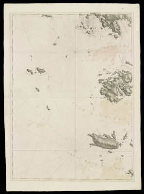
Coast of Maine- Detail of Penobscot Bay with Isle Haut and Southern Fox Island, Dated Aug. 17, 1776.
Collection: Osher Collection
Name: Coast of Maine- Detail of Penobscot Bay with Isle Haut and Southern Fox Island, Dated Aug. 17, 1776.
Barcode: 821
Creator: Anonymous / Unknown Author
From Atlas: No
Notes: Note lower right: "Publishd according to Act of Parliament Aug. 17th. 1776, by J.F.W. Des Barres Esqr." Title supplied by cataloger, no title on map itself.Map shows bays, harbours, islands and other landmarks: Seal Rock; Wooden Ball; Ragged Arge Island; Tenpound Island; Metimicus Island; No Mans Land; Green Islands; Metinick Island; Two Bush Island; The Muscle Ledge Islands; White Head; Seal Harbour; Seal Harbour Island; Remarkable Island; Birch Island; Birch Point; Owls Head Islands; Owls Head Harbour; Owls Head; Owls Head Bay; Penobscot Bay; Southern Harbour; Drunken Ledge; Southern Fox Island; Old Harbour; Pleasant River; Isle Haut Bay; South West Harbour; South West Harbour; Green Island; Fill Boat Island; Great Blue Hill Bay; Bear of Marshals Island.
Publisher: Des Barres, Joseph F. W. (Joseph Frederick Wallet), 1729-1824
Date/Date Range Produced: 1776
Date/Date Range Published: 1776
Language: English
Region Depicted: Isle au Haut, MaineKnox County, MainePenobscot Bay, MaineVinalhaven, Maine
Dimensions: H 105 x W 77 cm.
Printing Process: Engraving
Printing Technique: Copper
Material Type: Paper
LC Call Number:
OCLC:
Donor: Osher
Subjects: CoastsIslandsIsle au Haut (Me.)Knox County (Me.)Maine--MapsMaps--Early works to 1800Nautical chartsPenobscot Bay (Me.)Vinalhaven Island (Me.)
Permenant URL: https://oshermaps.org/map/821.0001