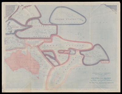
Sovereignty and Mandate Boundary Lines in 1921 of the Islands of the Pacific
Collection: Osher Map Library Collection
Name: Sovereignty and Mandate Boundary Lines in 1921 of the Islands of the Pacific
Barcode: 51021
Creator: Bumstead, Albert Hoit, 1875-1940Darley, James Morrison
From Atlas: No
Notes: Note below neat line: "Drawn by Albert H. Bumstead and James M. Darley"Note: "Sanson-Flamsteed Equal Area Projection."Shows cable lines.Issued with the National Geographic magazine, v. 40, no. 6, Dec. 1921.
Publisher: National Geographic Society (U.S.)
Date/Date Range Produced: 1921
Date/Date Range Published: 1921
Dimensions: 46 x 61 cm
LC Call Number: G9231.F3 1921 .N3
OCLC: 5676710
Donor: Dalton
Permenant URL: https://oshermaps.org/map/51021.0001