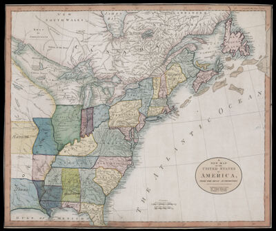
A New Map of the United States of America, from the best authorities.
Collection: Osher Map Library Collection
Name: A New Map of the United States of America, from the best authorities.
Barcode: 50004
Creator: Wallis, J. (John), -1818
From Atlas: No
Notes: Previously unknown second state of the Wallis map of the United States, updated to show the the United States at the tail end of the War of 1812.Published 29 years after the first state, the map has been updated to add Vermont, Ohio, Kentucky, "Tennaseee," and Western Territory. The map has also been extensively annotated by possibly two early hands, showing Chicago, Indiana, Michigan, Iowa, Kansas, Texas, Missouri, Arkansas, Mississippi and Alabama.
Publisher: Wallis, J. (John), -1818
Date/Date Range Produced: 1814
Date/Date Range Published: Oct 1st, 1814
Language: English
Region Depicted: Eastern CanadaEastern United StatesNortheastern StatesUnited States
Map Type: GeographicalPolitical maps
Dimensions: 46 x 55 cm
Printing Process: Engraving
Printing Technique: Copper
Material Type: Paper
LC Call Number:
OCLC: 973940282
See Also: The United States of America laid down from the best Authorities, agreeable to the Peace of 1783. Published, April 3rd, 1783 by the Proprietor John Wallis, at his Map-Warehouse , Ludgate Street London.
Permenant URL: https://oshermaps.org/map/50004.0001