United States of America
Collection: Osher Map Library Collection
Name: United States of America
Barcode: 49230
Creator: Allen, W.Dawson, E. B.Knight, J. (Engraver)Tanner, Henry Schenck, 1786-1858
From Atlas: No
Publishing Location: Philadelphia
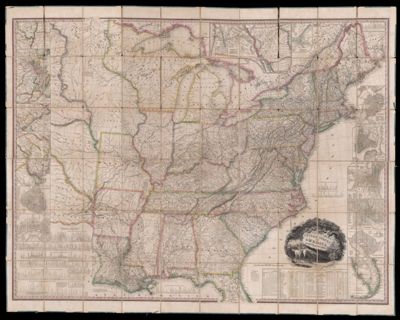
Notes: Includes inset maps: Boston; New York; Philadelphia; Baltimore; Washington; South Part of Florida; New Orleans; Charleston; Environs of Savannah; Environs of Baltimore and Washington; Environs of Philadelphia and Trenton; Environs of New York; Environs of Boston; Environs of Albany;Profiles, and statistical tables. Also included are population statistics of the United States from 1820. Decorative cartouche with nature scene and countryside.Information about the heights and depths of canals and railroads.Gift of Ethel Bean Turner 9/14/2015
Publisher: Tanner, Henry Schenck, 1786-1858
Date/Date Range Produced: 1829
Date/Date Range Published: 1829
Language: English
Region Depicted: Eastern United States
Map Type: Wall maps
Dimensions: folded to 21 x 16 cm.
LC Call Number: G3700 1829.T3
OCLC: 6506987
Subjects: Albany, NYBaltimoreBoston (Mass.)CanalsCensusCharleston (S.C.)Eastern United StatesFloridaGreat Lakes (North America)Indigenous peopleNative AmericansNew OrleansNew York (N.Y.)North American IndiansPittsburgh (Pa.)RailroadsRoad mapsTanner, Henry Schenck, 1786-1858Washington D.C.
Permenant URL: https://oshermaps.org/map/49230.0001