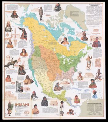
Indians of North America / North America before Columbus
Collection: Osher Map Library Collection
Name: Indians of North America / North America before Columbus
Barcode: 51468
From Atlas: No
Notes: Includes text, map and chart "A chronicle of the North American past," and col. illShows tribal locations, historical and battle sites. Shows development of aboriginal North Americans from ca. 10,000 B.C. to the 16th century A.D. Insets: Ipiutak, Alaska -- Edwin Harness Site, Ohio --Moundville, Alabama -- Tenochtitlán, Mexico --Tyuonyi Pueblo, New Mexico
Publisher: National Geographic Society (U.S.)
Date/Date Range Produced: 1974
Date/Date Range Published: 1974
Language: English
Region Depicted: Central AmericaNorth America
Dimensions: 95 x 82.5 cm
LC Call Number: G3301.E1 1974 .N3
OCLC: 221898499
Donor: Neuschaffer
Subjects: AnthropologyArchaeologyColonialismNative American tribes
Permenant URL: https://oshermaps.org/map/51468.0001