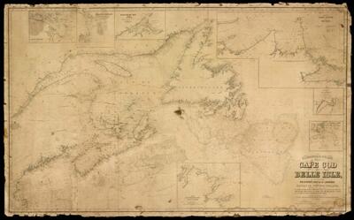
Eldridge's Chart from Cape Cod to Belle Isle : including the Bay of Fundy, Gulf of St. Lawrence, and banks of Newfoundland, with plans on a large scale of the coast of Nova Scotia from Cape Canso to Pictou, the coast of Cape Breton from Scatari to Sydney, and the harbors of St. Johns N.F. St. John, N.B., Halifax, Miramichi, & Cape Canso.
Collection: Osher Collection
Name: Eldridge's Chart from Cape Cod to Belle Isle : including the Bay of Fundy, Gulf of St. Lawrence, and banks of Newfoundland, with plans on a large scale of the coast of Nova Scotia from Cape Canso to Pictou, the coast of Cape Breton from Scatari to Sydney, and the harbors of St. Johns N.F. St. John, N.B., Halifax, Miramichi, & Cape Canso.
Barcode: 14822
Creator: Carpenter, E.W.Eldridge, Geo. W. (George Washington), 1845-1914
Date/Date Range Produced: 1869
Date/Date Range Published: 1869
Language: English
Dimensions: x
Notes: Inset map: Canso Harbor, Halifax Harbor, Miramachi Bay and River, from Cape Canso to Pictou, harbor of St. Johns, harbor of St. John, from Scatari Island to Sydney Harbor.
Note: "Published by E.W. Carpenter. Geo. Eldridge, Hydrographer. Sold by S. Thaxter & Son, 125 State St. Boston."
OCLC: 649716132
Accession Number: OS-1869-21
Donor: Osher
Permenant URL: https://oshermaps.org/map/14822.0001