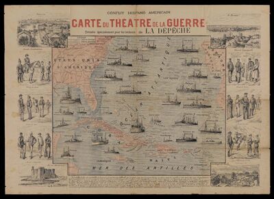
Conflit Hispano Americain : Carte du Theatre de la Guerre / Dressee Specialement pour les Lecteurs de La Depeche
Collection: Osher Map Library Collection
Name: Conflit Hispano Americain : Carte du Theatre de la Guerre / Dressee Specialement pour les Lecteurs de La Depeche
Barcode: 49886
Printmaker: Charaire, E.
Publisher: La Depeche
Date/Date Range Produced: 1898
Date/Date Range Published: 1898
Language: French
Region Depicted: Caribbean regionCaribbean SeaCubaWest Indies
Dimensions: 52 x 72 cm
Notes: This colored map was issued as a supplement to La Depeche, a newspaper published in Toulouse, France. The map depicts the naval fleets of the United States and Spain in the West Indies and Northern Atlantic Ocean at the outbreak of the Spanish-American War. The map includes uncolored vignettes of American, Cuban, and Spanish soldiers and seamen in military uniform. Also includes views of Santiago de Cuba, Fort des Boucaniers, Matanzas, and Havana, as well as descriptive text beneath the map. This map was presumably published sometime in April 1898, at the beginning of the conflict, because the text on the map mentions a hypothetical American blockade of Havana. According to historian David Trask, “Admiral William Sampson immediately established a blockade of Havana” at the outset of the war on April 21, 1898, which seems to indicate this map was printed before (or very close to) that date.
Accession Number: OML-1898-87
Subjects: BattleshipsSoldiersSpanish-American War, 1898
Permenant URL: https://oshermaps.org/map/49886.0001