Collection: Osher Map Library Collection
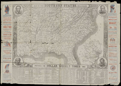
Name: Map of the Southern States including rail roads, county towns, state capitals, county roads, the southern coast from Delaware to Texas, showing harbors, inlets, forts and position of blockading ships prepared for Dollar Weekly Times 1862
Barcode:
Publishing Location:
Publisher:
Date/Date Range Published:
Language:
Map Type:
Dimensions: 50 x 76 cm on sheet 65 x 94 cm
LC Call Number: G3861.S5 1862 S7
OCLC: 1119721984
Permenant URL: