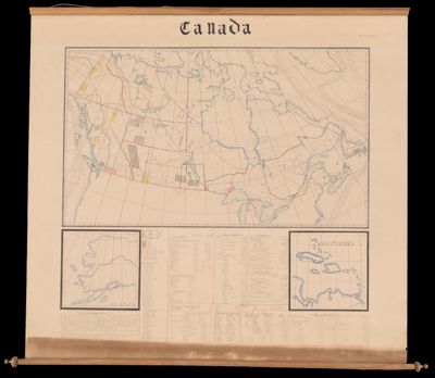
Canada
Collection: Osher Map Library Collection
Name: Canada
Barcode: 53751
Creator: Harris, Margaret M.
From Atlas: No
Notes: Hand-drawn map wall map. Harris was a young school teacher in Digby, Nova ScotiaInsets included: Alaska; West Indies.Contains information on large variety of topics: Notes of government; Fisheries; Animals; Population; Length of rivers; Area of lakes; Height of noted mountain peaks; Minerals; Farm stock; Wealth; Grains; Ports open all the year; Forestry; Value of agriculture.
Date/Date Range Produced: 1904
Language: English
Region Depicted: AlaskaCanadaWest Indies
Map Type: Manuscript mapsWall maps
Dimensions: 113 x 122 cm
LC Call Number:
OCLC:
Donor: Holmberg
Subjects: AgricultureAlaskaAnimalsCanadaCensusEconomicsFarmingFishingForestryMines and mineral resourcesMountainsOcean currentsRailroadsRivers and lakesWest IndiesWindsWomen cartographers
Permenant URL: https://oshermaps.org/map/53751.0001