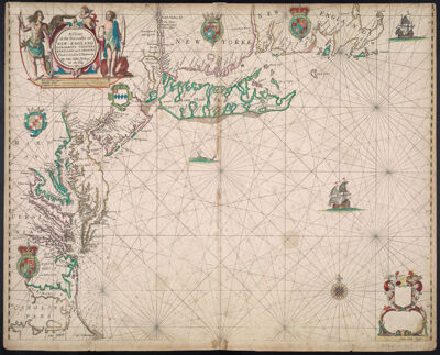
A Chart of the Sea coasts of New England, New Jarsey, Virginia, Maryland and Carolina From C. Cod to C. Hatteras By John Seller Hydrogr. to the King
Collection: Osher Collection
Name: A Chart of the Sea coasts of New England, New Jarsey, Virginia, Maryland and Carolina From C. Cod to C. Hatteras By John Seller Hydrogr. to the King
Barcode: 483
Creator: Seller, John, active 1658-1698
Printmaker: Clerk, James, active 1680-1695
From Atlas: Yes
Notes: Note in lower right corner: "Iames Clerk sculpsit."
Publisher: Seller, John, active 1658-1698
Date/Date Range Produced: 1675
Date/Date Range Published: 1675
Language: English
Region Depicted: Atlantic StatesConnecticutDelawareLong Island, New YorkMarylandMassachusettsMiddle Atlantic StatesNew EnglandNew JerseyNew York (State)North CarolinaPennsylvaniaRhode IslandVirginia
Map Type: GeographicalNautical chartsPolitical maps
Dimensions: 45 x 55 cm.
Printing Process: Engraving
Printing Technique: Copper
Material Type: Paper
OCLC: 841172485
Accession Number: OS-1675-3
Donor: Osher
Subjects: AnimalsAnimalsBaysCartouches, Ornamental (Decorative arts)Cherubs (Art)Clerk, James, active 1680-1695Clothing and dressCoastsConnecticutDeerDelawareDevices (Heraldry)Devices (Heraldry)DogsHeraldryImaginary creaturesIndians of North AmericaIndigenous peopleLong Island (N.Y.)Manners and customsMaps--Early works to 1800MarylandMassachusettsMiddle Atlantic StatesNative AmericansNautical chartsNew EnglandNew JerseyNew York (State)North CarolinaRhode IslandSea monstersSeller, John, active 1658-1698VirginiaWhales
Permenant URL: https://oshermaps.org/map/483.0001