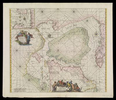
Septentrionaliora Americae Groenlandia, per Freta Davidis et Hudson at Terram Novam
Collection: Smith Collection
Name: Septentrionaliora Americae Groenlandia, per Freta Davidis et Hudson at Terram Novam
Barcode: 1866
Creator: Wit, Frederik de
From Atlas: Yes
Publishing Location: Amsterdam
Notes: From: "Atlas de la Navigation". Included in de Wit's 1675 atlas. Louis Renard published Atlas de la Navigation in 1715 using de Wit plates. In 1739 R. & J. Ottens published two atlases, one with Renard's name and the other with their own. In 1745 Ottens reset a new title page without Renard's name and included this map.
Atlas Reference: Atlas de la Navigation
Subjects: Array
Date/Date Range Produced: 1739
Date/Date Range Published: 1739
Language: DutchLatin
Region Depicted: Baffin BayGreenlandHudson BayManitoba, CanadaNewfoundland and LabradorNorthern CanadaNunavut, CanadaOntario
Map Type: GeographicalNautical charts
Dimensions: H 54.3 x W 63.8 cm
Printing Process: Engraving
Printing Technique: Copper
Material Type: Paper
LC Call Number: G3300 .W5 1739
OCLC: 173665784
Donor: Smith
Permenant URL: https://oshermaps.org/map/1866.0001