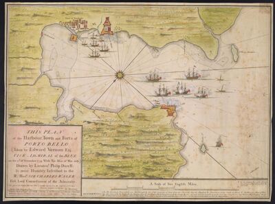
This Plan of the Harbour, Town, and Forts of Porto Bello (taken by Edward Vernon, Esqr. Vice Admiral of the Blue on the 22d of November 1739 With Six Men of War only) Drawn by Lieutent. Philip Durell, Is most Humbly Inscribed to the Rt. Honble. Sir Charles Wager First Lord Commisioner of the Admiralty. I do assure the publick that this Plan is exactly copied from the Original (and only) Drawing brought over by me, Ja. Rentone
Collection: Smith Collection
Name: This Plan of the Harbour, Town, and Forts of Porto Bello (taken by Edward Vernon, Esqr. Vice Admiral of the Blue on the 22d of November 1739 With Six Men of War only) Drawn by Lieutent. Philip Durell, Is most Humbly Inscribed to the Rt. Honble. Sir Charles Wager First Lord Commisioner of the Admiralty. I do assure the publick that this Plan is exactly copied from the Original (and only) Drawing brought over by me, Ja. Rentone
Barcode: 1868
Creator: Durell, Philip,-1766Harding, Samuel, -1755Toms, W. H. (William Henry), approximately 1700-1765
Date/Date Range Produced: 1740
Date/Date Range Published: 1740
Language: English
Dimensions: 38 x 58
Printing Process: Etching
Printing Technique: Copper
Material Type: Paper
Notes: Note: "Published March 27th, 1740 and Sold by S. Harding on the Pavement in St Martin's Lane, and W.H. Toms Engraver in Union Court near Hatton Garden Holborn. Price One Shilling."
Notes above the neat line: "P. Durell, delin. November 1739." "W.H. Toms Sculpt. 1740."
Oriented with north toward the lower left
Includes index and illustrations
LC Call Number: G4872.P6 1740 .D8
OCLC: 49247543
Accession Number: SM-1740-10
Donor: Smith
Permenant URL: https://oshermaps.org/map/1868.0001