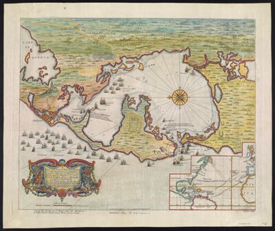
A New and Correct Plan of the Harbour of Carthagena in America Seated 16 Degrees 26 Minutes Lat. north and 75 degrees 21 Long. West of London, from a Draught brought to England by by Pet. Chassereau Archi: Also a View of the Fleet as they Anchor'd on ye Coast of Playa Grande & as they after moved to ye Forts St. Iago St. Philip & Boccachica & after into ye Harbour in Order to Beseige ye Town agreeable to ye Acct. brought over by Capt. Laws.
Collection: Smith Collection
Name: A New and Correct Plan of the Harbour of Carthagena in America Seated 16 Degrees 26 Minutes Lat. north and 75 degrees 21 Long. West of London, from a Draught brought to England by by Pet. Chassereau Archi: Also a View of the Fleet as they Anchor'd on ye Coast of Playa Grande & as they after moved to ye Forts St. Iago St. Philip & Boccachica & after into ye Harbour in Order to Beseige ye Town agreeable to ye Acct. brought over by Capt. Laws.
Barcode: 1879
Creator: Bowles, Thomas, -1767Chassereau, Pierre
Date/Date Range Produced: 1741
Date/Date Range Published: 1741
Language: English
Dimensions: 41 x 50
Printing Process: Engraving
Printing Technique: Copper
Material Type: Paper
Notes: Illustrations include naval battle scenes and French troops seizing treasure. Included are details relating to the siege in 1697 and the French ships involved in the conflict
Inset map includes routes of ships crossing the Atlantic
R. Parr
LC Call Number: G5294 .C4 1741
OCLC: 173314834
Accession Number: SM-1741-8
Donor: Smith
Permenant URL: https://oshermaps.org/map/1879.0001