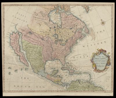
A Map of North America With the European Settlements & whatever else is remarkable in ye West Indies, from the latest and best observations.
Collection: Smith Collection
Name: A Map of North America With the European Settlements & whatever else is remarkable in ye West Indies, from the latest and best observations.
Barcode: 1885
Creator: Seale, Richard William
Notes: Note below neat line: " R. W. Seale delin. et sculp."Shows California as an island.Shows locations of European cities and towns, Indian towns, forts and castles.From: Paul Rapin de Thoyras' "The History of England," continued by N. Tindal. London, 1744. volume 3
Date/Date Range Produced: 1744
Date/Date Range Published: 1744
Language: English
Region Depicted: North AmericaWest Indies
Dimensions: H 40 x W 48.1 cm
Printing Process: Engraving
Printing Technique: Copper
Material Type: Paper
LC Call Number: G3300 .S4 1744
OCLC: 68914634
Donor: Smith
Permenant URL: https://oshermaps.org/map/1885.0001