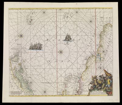
Terra Neuf, en de Custen van Nieu Vranckryck, Nieu Engeland, Nieu Nederland, Nieu Andalusia, Guiana en Venezuela t'Amsterdam Gedruckt by R. & I. Ottens
Collection: Smith Collection
Name: Terra Neuf, en de Custen van Nieu Vranckryck, Nieu Engeland, Nieu Nederland, Nieu Andalusia, Guiana en Venezuela t'Amsterdam Gedruckt by R. & I. Ottens
Barcode: 1887
Creator: Wit, Frederik de
From Atlas: Yes
Publishing Location: Amsterdam
Notes: Originally published by Frederick de Wit in 1675. In 1715 Louis Renard used the de Wit plates for his navigational atlas. In 1739 and 1745 Ottens edited the de Wit /Renard charts and maps and published them in a new atlas.
Publisher: R. & J. Ottens
Date/Date Range Produced: 1745
Date/Date Range Published: 1745
Language: Dutch
Region Depicted: Atlantic OceanMiddle Atlantic StatesNew EnglandVenezuelaWest Indies
Map Type: GeographicalNautical charts
Dimensions: H 54.8 x W 63.2 cm
Printing Process: Engraving
Printing Technique: Copper
Material Type: Paper
LC Call Number: G9110 .W5
OCLC: 173315016
Donor: Smith
Subjects: AnimalsArmadillosAtlantic OceanBrazilCamelsCartouches, Ornamental (Decorative arts)ExplorersFrench GuianaGuyanaMiddle Atlantic StatesNative AmericansNaval battlesNew EnglandSailing shipsSurinameVenezuelaWest IndiesWhirlpools
Permenant URL: https://oshermaps.org/map/1887.0001