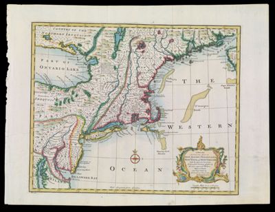
A New and Accurate Map of New Jersey, Pensilvania, New York and New England, with the adjacent Countries. Drawn from Surveys, assisted by the most approved Modern Maps & Charts, and Regulated by Astronomical Observations. By Eman. Bowen copy 2
Collection: Smith Collection
Name: A New and Accurate Map of New Jersey, Pensilvania, New York and New England, with the adjacent Countries. Drawn from Surveys, assisted by the most approved Modern Maps & Charts, and Regulated by Astronomical Observations. By Eman. Bowen copy 2
Barcode: 1895
Creator: Bowen, Emanuel, 1693 or 1694-1767
From Atlas: Yes
Notes: Copy 2 of SM-1747-7; copy 1 is uncolored. From the author's "A Complete System of Geography." 1747. Note lower left: "No. 100. "
Atlas Reference: A Complete System of Geography, 1747
Subjects: Array
Date/Date Range Produced: 1747
Date/Date Range Published: 1747
Language: English
Region Depicted: New EnglandNew JerseyNew YorkPennsylvania
Map Type: Geographical
Dimensions: H 41.2 x W 54.6 cm
Printing Process: Engraving
Printing Technique: Copper
Material Type: Paper
LC Call Number:
OCLC: 5402713
See Also: A New and Accurate Map of New Jersey, Pensilvania, New York and New England, with the adjacent Countries. Drawn from Surveys, assisted by the most approved Modern Maps & Charts, and Regulated by Astronomical Observations. By Eman. Bowen copy 1
Donor: Smith
Permenant URL: https://oshermaps.org/map/1895.0001