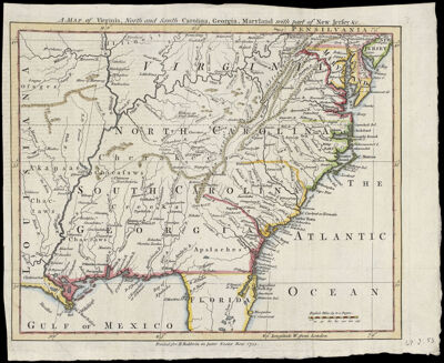
A Map of Virginia, North and South Carolina, Georgia, Maryland with part of New Jersey &c.
Collection: Smith Collection
Name: A Map of Virginia, North and South Carolina, Georgia, Maryland with part of New Jersey &c.
Barcode: 1919
Date/Date Range Produced: 1755
Date/Date Range Published: 1755
Language: English
Dimensions: 21 x 26
Printing Process: Engraving
Printing Technique: Copper
Material Type: Paper
Notes: Note: "Printed for R. Baldwin in pater Noster Row 1755."
Shows provinces, coastal towns and a few frontier settlements, Indian villages and tribal territory, English "Factories" among the Indians, mines, rivers, numerous place-names.
From: The Gentleman's Magazine and Historical Chronicle (July, 1755), vol. 24.
Appears to be based on the work of John Mitchell.
LC Call Number: G3870 1755 .M37
OCLC: 26481320
Accession Number: SM-1755-27
Donor: Smith
Permenant URL: https://oshermaps.org/map/1919.0001