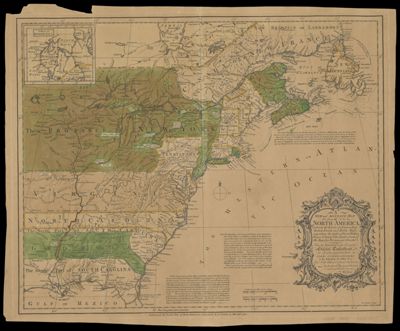
A New and Accurate Map of North America, (wherein the Errors of all preceeding British, French and Dutch maps, respecting the rights of Great Britain, France & Spain & the Limits of each of His Majesty's Provinces, are Corrected)
Collection: Smith Collection
Name: A New and Accurate Map of North America, (wherein the Errors of all preceeding British, French and Dutch maps, respecting the rights of Great Britain, France & Spain & the Limits of each of His Majesty's Provinces, are Corrected)
Barcode: 1922
Creator: Huske, John, 1721?-1773Kitchin, Thomas, 1718-1784R. and J. Dodsley
Notes: Notes: "Humbly inscribed to the Honorable Charles Townshend, one of the Right Honorable Lords Commissioners for executing the Office of Lord High Admiral of Great Britain &c. By his Most Obliged, most Obedient and Very Humble Servant Huske." "Tho: Kitchin, Sculpt."Inset map: "A Map of Hudsons Bay &c."Includes explanatory text.
Date/Date Range Produced: 1755
Date/Date Range Published: 1755
Language: English
Region Depicted: Eastern CanadaEastern United States
Dimensions: H 43 x W 52.8 cm
Printing Process: Engraving
Printing Technique: Copper
Material Type: Paper
LC Call Number: G3300 1755 .H8
OCLC: 55073980
Donor: Smith
Permenant URL: https://oshermaps.org/map/1922.0001