Collection: Smith Collection
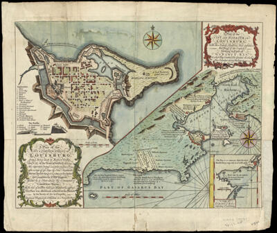
Name: A Plan of the City and Harbour of Louisburg, with the French Batteries that defended it and Those of the English shewing that part of Gabarus Bay in which They Landed & the Ground on which They Encamped during the Siege of 1745
Barcode:
Creator:
Notes:
Date/Date Range Produced:
Date/Date Range Published:
Language:
Region Depicted:
Dimensions: H 33.2 x W 38.8 cm
Printing Process:
Printing Technique:
Material Type:
LC Call Number: G3424.L6 H5 1757
OCLC: 138099973
Donor:
Permenant URL: