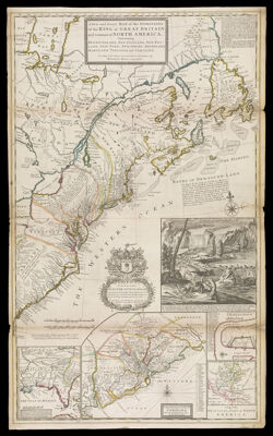
A New and Exact Map of the Dominions of the King of Great Britain on ye Continent of North America. Containing Newfoundland, New Scotland, New England, New York, New Jersey, Pensilvania, Maryland, Virginia and Carolina. According to Newest and most Exact Observations. By Herman Moll Geographer.
Collection: Osher Collection
Name: A New and Exact Map of the Dominions of the King of Great Britain on ye Continent of North America. Containing Newfoundland, New Scotland, New England, New York, New Jersey, Pensilvania, Maryland, Virginia and Carolina. According to Newest and most Exact Observations. By Herman Moll Geographer.
Barcode: 632
Creator: Moll, Herman, 1654 -1732
Notes: Inset maps: Louisiana and Carolina, "A Draught of ye town and ye Harbour of Charles-Town," "A Map of the principal part of North America," "A Map of the improved part of Carolina with the settlements."Note: "To the Honourable Walter Dowglass Esqr. Constituted Captain General...by her late Majesty Queen Anne in ye year 1711. This Map is most Humbly Dedicated by your most Humble Servant Herman Moll Geographer."
Date/Date Range Produced: 1732
Date/Date Range Published: 1732
Language: English
Dimensions: H 105 x W 64 cm
Printing Process: Engraving
Printing Technique: Copper
Material Type: Paper
LC Call Number:
OCLC: 226392438
Donor: Osher
Permenant URL: https://oshermaps.org/map/632.0001