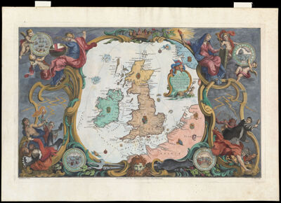
A Chart Shewing the Several Places of Action between the English and Spanish Fleets with the Places where several of the Spanish Ships were destroyed in their return to Spain, North about the British Isles.
Collection: Osher Collection
Name: A Chart Shewing the Several Places of Action between the English and Spanish Fleets with the Places where several of the Spanish Ships were destroyed in their return to Spain, North about the British Isles.
Barcode: 641
Creator: Gravelot, Hubert François, 1699-1773Pine, John, 1690-1756
Notes: Illustrates the movements of the Spanish Armada in 1588Elaborate colored illustrations around the borders of the map, copied from a tapestry in the House of Lords, depicting the allegorical figures of victorious England and defeated Spain. Medallions in the four corners of the sheet show scenes from Maritime battle. Bottom center: "Published by John Pine, June 24. 1739, according to Act of Parliament."
Date/Date Range Produced: 1739
Date/Date Range Published: 1739
Language: English
Dimensions: H 47.5 x W 67.7 cm
Printing Process: Engraving
Printing Technique: Copper
Material Type: Paper
LC Call Number:
OCLC: 854765426
Donor: Osher
Permenant URL: https://oshermaps.org/map/641.0001