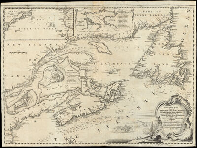
A New Chart of the Coast of New England, Nova Scotia, New France or Canada, with the Islands of Newfoundld. Cape Breton St. John's &c. Done from the Original Publish'd in 1744. at Paris, by Monsr. N. Bellin, Engineer to the Marine Office. This Chart is Most humbly Dedicated to the Britsh. Merchts., trading to North America, by the Editor.
Collection: Osher Collection
Name: A New Chart of the Coast of New England, Nova Scotia, New France or Canada, with the Islands of Newfoundld. Cape Breton St. John's &c. Done from the Original Publish'd in 1744. at Paris, by Monsr. N. Bellin, Engineer to the Marine Office. This Chart is Most humbly Dedicated to the Britsh. Merchts., trading to North America, by the Editor.
Barcode: 654
Creator: Bellin, Jacques NicolasJefferys, Thomas, 1710-1771
Notes: From: Gentleman's Magazine Jan. 1746 (Text in Feb. '46)Inset maps: "North New France or Canada" "Plan of the City and Port of Louisbourg" "City of Quebec"Note: "This chart is most humbly dedicated to The Britsh. Merchts. trading to North America by the Editor."
Date/Date Range Produced: 1746
Date/Date Range Published: 1746
Language: English
Dimensions: H 35.1 x W 47.3 cm
Printing Process: Etching
Printing Technique: Copper
Material Type: Paper
LC Call Number:
OCLC: 456362065
Donor: Osher
Permenant URL: https://oshermaps.org/map/654.0001