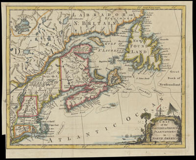
A Map of the British and French Plantations in North America
Collection: Osher Collection
Name: A Map of the British and French Plantations in North America
Barcode: 681
Creator: London Magazine
From Atlas: No
Notes: From The London Magazine, August 1755, vol. 24, p. 360.
Date/Date Range Produced: 1755
Date/Date Range Published: 1755
Language: English
Region Depicted: CanadaConnecticutLong Island, New YorkMaineMaritime ProvincesMassachusettsNew EnglandNew HampshireNewfoundland and LabradorNova ScotiaRhode IslandVermont
Map Type: GeographicalPolitical maps
Dimensions: H 22.5 x W 27.7 cm
Printing Process: Engraving
Printing Technique: Copper
Material Type: Paper
LC Call Number:
OCLC: 255332785
Donor: Osher
Permenant URL: https://oshermaps.org/map/681.0001