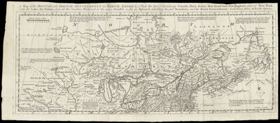
A Map of the British and French Settlements in North America: [Part the first] Containing Canada, Nova Scotia, New found land, New England, part of New York, with the lakes, Six Nations, and all the Countries Westward in the same Parallels so far as Discover'd, exhibiting the just Boundaries, and the French Encroachments: laid down from authentic surveys
Collection: Osher Collection
Name: A Map of the British and French Settlements in North America: [Part the first] Containing Canada, Nova Scotia, New found land, New England, part of New York, with the lakes, Six Nations, and all the Countries Westward in the same Parallels so far as Discover'd, exhibiting the just Boundaries, and the French Encroachments: laid down from authentic surveys
Barcode: 685
Creator: Bowen, Emanuel, 1693 or 1694-1767
Printmaker: Bowen, Thomas, -1790
From Atlas: No
Notes: Note lower right: "T. Bowen sculpt."
Date/Date Range Produced: 1755
Date/Date Range Published: 1755
Language: English
Region Depicted: CanadaConnecticutGreat Lakes Region (North America)IllinoisIndianaMaineMaritime ProvincesMassachusettsMichiganMinnesotaNew EnglandNew HampshireNew York (State)Newfoundland and LabradorNova ScotiaOhioOntarioPennsylvaniaRhode IslandVermontWisconsin
Map Type: GeographicalPolitical maps
Dimensions: H 21.9 x W 51.2 cm
Printing Process: Engraving
Printing Technique: Copper
Material Type: Paper
LC Call Number:
OCLC: 43214021
Donor: Osher
Permenant URL: https://oshermaps.org/map/685.0001