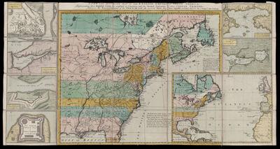
A New and Accurate Map of the English Empire in North America: Representing their Rightful Claim as confirmed by Charters ...
Collection: Osher Collection
Name: A New and Accurate Map of the English Empire in North America: Representing their Rightful Claim as confirmed by Charters ...
Barcode: 692
Creator: Society of Anti-Gallicans
From Atlas: No
Notes: This map is commonly known as the "Anti-Gallican map" or "Anti-Gallicans map."
To see the slipcase for this item go to oshermaps.org/map/40843.0001
Publisher: Herbert, William, 1718-1795Sayer, Robert, 1725-1794
Date/Date Range Produced: 1755
Date/Date Range Published: 1755
Language: English
Region Depicted: Cape Breton IslandEastern CanadaEastern United StatesGreat Plains (North America)North AmericaNova Scotia
Map Type: Geographical
Dimensions: 44 X 81 cm.
Printing Process: Engraving
Printing Technique: Copper
Material Type: Paper
LC Call Number:
OCLC: 5412729
Accession Number: OS-1755-3
Donor: Osher
Subjects: Canada, EasternColonial AmericaEast (U.S.)Great PlainsPropaganda
Permenant URL: https://oshermaps.org/map/692.0001