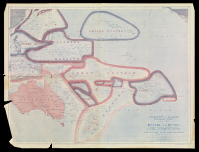
Sovereignty and Mandate Boundary Lines in 1921 of the Islands of the Pacific prepared in the Map Department of the National Geographic Society for the National Geographic Magazine Gilbert Grosvenor, Editor
Collection: Story Collection
Name: Sovereignty and Mandate Boundary Lines in 1921 of the Islands of the Pacific prepared in the Map Department of the National Geographic Society for the National Geographic Magazine Gilbert Grosvenor, Editor
Barcode: 4830
Creator: Bumstead, Albert Hoit, 1875-1940Darley, James MorrisonNational Geographic Society (U.S.) Cartographic Division
Publishing Location: Washington D.C.
Notes: Note below neat line: "Drawn by Albert H. Bumstead and James M. Darley"
Note: "Sanson-Flamsteed Equal Area Projection."
Shows cable lines.
Issued with the National Geographic magazine, v. 40, no. 6, Dec. 1921.
Date/Date Range Produced: 1921
Language: English
Region Depicted: Hawaiian IslandsMelanesiaMicronesiaNew GuineaNew ZealandPapua New GuineaPhilippinesPolynesiaTuamotu Archipelago, French Polynesia
Dimensions: 46 x 61
LC Call Number: G9231.F3 1921 .N3
OCLC: 5676710
Accession Number: ST-1921-22
Donor: Story
Permenant URL: https://oshermaps.org/map/4830.0001