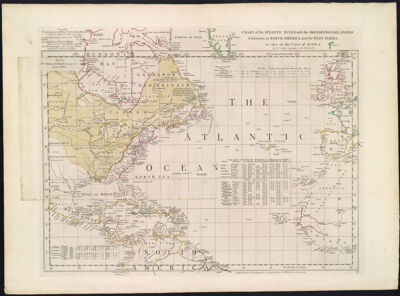
Chart of the Atlantic Ocean, with the British, French, & Spanish Settlements in North America, and the West Indies, as also on the Coast of Africa. By Thos. Jefferys Geographer to His Majesty.
Collection: Osher Collection
Name: Chart of the Atlantic Ocean, with the British, French, & Spanish Settlements in North America, and the West Indies, as also on the Coast of Africa. By Thos. Jefferys Geographer to His Majesty.
Barcode: 746
Creator: Jefferys, Thomas, 1710-1771
From Atlas: No
Notes: Bottom right corner: "Published according to Act of Parliament by T. Jefferys the Corner of St. Martins Lane. Charing Cross." .
Date/Date Range Produced: 1763
Date/Date Range Published: 1763
Language: English
Region Depicted: AlgeriaAtlantic OceanAzoresBahamasBritish IslesBurkina FasoCanadaCanary IslandsCape VerdeCaribbean regionCentral AmericaColombiaCôte d'IvoireCubaDominican RepublicEcuadorEnglandFranceFrench GuianaGambiaGhanaGreat BritainGreater AntillesGuineaGuinea-BissauGuyanaHaitiIrelandJamaicaLesser AntillesMaliMauritaniaMoroccoNorth AmericaPortugalPuerto RicoScotlandSenegalSierra LeoneSpainSurinameUnited StatesVenezuelaWalesWest AfricaWest IndiesWestern Sahara
Map Type: GeographicalHistorical mapsPolitical maps
Dimensions: 42 x 61 cm.
Printing Process: Engraving
Printing Technique: Copper
Material Type: Paper
LC Call Number:
OCLC: 5405006
Accession Number: OS-1763-3
Donor: Osher
Subjects: Africa, WestAtlantic OceanCaribbean AreaCentral AmericaColombiaColonial AmericaEcuadorFrench GuianaGuyanaMaps--Early works to 1800North AmericaSurinameVenezuela
Permenant URL: https://oshermaps.org/map/746.0001