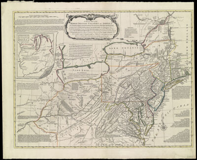
A General Map of the Middle British colonies in America viz. Virginia, Maryland, Delaware, Pensilvania, New-Jersey, New York, Connecticut & Rhode-Island: of Aquanishuonigy the country of the Confederate Indians Comprehending Aquanishuonigy proper, their Places of Residence, Ohio & Thuchsochruntie their Deer Hunting Countries, Couchsachrage & Skaniadarade their Beaver Hunting Countries, of the Lakes Erie, Ontario and Champlain. Wherein is also shewn the antient & present Seats of the Indian Nations: carefully copied from the original published at Philadelphia, by Mr. Lewis Evans.
Collection: Osher Collection
Name: A General Map of the Middle British colonies in America viz. Virginia, Maryland, Delaware, Pensilvania, New-Jersey, New York, Connecticut & Rhode-Island: of Aquanishuonigy the country of the Confederate Indians Comprehending Aquanishuonigy proper, their Places of Residence, Ohio & Thuchsochruntie their Deer Hunting Countries, Couchsachrage & Skaniadarade their Beaver Hunting Countries, of the Lakes Erie, Ontario and Champlain. Wherein is also shewn the antient & present Seats of the Indian Nations: carefully copied from the original published at Philadelphia, by Mr. Lewis Evans.
Barcode: 750
Creator: Evans, Lewis, 1700?-1756
From Atlas: No
Notes: Note: "London, Printed for John Bowles at The Black Horse in Cornhil, & Carington Bowles in St. Paul's Church Yard." 1765 - Questionable .
Publisher: Bowles, Carington, 1724-1793Bowles, John, 1701-1779
Date/Date Range Produced: 1765
Date/Date Range Published: 1765
Language: English
Region Depicted: ConnecticutDelawareIndianaKentuckyMarylandMassachusettsMichiganNew JerseyNew York (State)North CarolinaNortheastern StatesOhioOntarioPennsylvaniaRhode IslandTennesseeVirginiaWest Virginia
Map Type: GeographicalHistorical mapsPolitical maps
Dimensions: 49 x 65 cm. folded in cover 29 x 21 cm.
Printing Process: Engraving
Printing Technique: Copper
Material Type: Paper
LC Call Number:
OCLC: 5445176
Donor: Osher
Permenant URL: https://oshermaps.org/map/750.0001