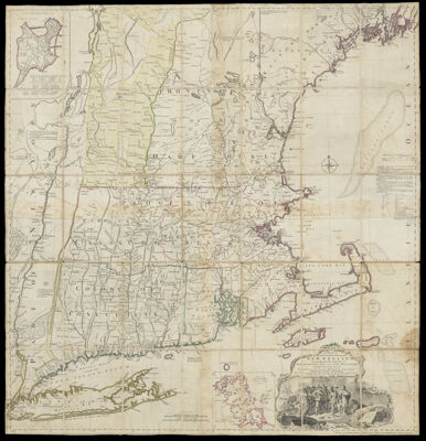
A Map of the most Inhabited part of New England, containing the Provinces of Massachusetts Bay and New Hampshire, with the Colonies of Conecticut and Rhode Island, Divided into Counties and Townships: The Whole composed from Actual Surveys and its Situation adjusted by Astronomical Observations.
Collection: Osher Collection
Name: A Map of the most Inhabited part of New England, containing the Provinces of Massachusetts Bay and New Hampshire, with the Colonies of Conecticut and Rhode Island, Divided into Counties and Townships: The Whole composed from Actual Surveys and its Situation adjusted by Astronomical Observations.
Barcode: 753
Creator: Green, John, active 1730-1753Jefferys, Thomas, 1710-1771
Notes: Note lower right: "November 29th. 1755 Published according to Act by Thomas Jefferys Geographer to His Royal Highness the Prince of Wales near Charing Cross"Sectioned on linen; with Percy BookplateDecorative cartouche illustrated with colonists and nativesJohn Green was an alias. He was originally born Bradock Mead in Ireland, likely before 1688.
Date/Date Range Produced: 1755 - 1768
Language: English
Region Depicted: ConnecticutMaineMassachusettsNew EnglandNew HampshireNew YorkRhode IslandVermont
Dimensions: H 106 x W 101 cm
LC Call Number: G3720 1768.J4
OCLC: 986799592
Donor: Osher
Subjects: Colonial America
Permenant URL: https://oshermaps.org/map/753.0001; 753.0002